.jpg)
.jpg)
The New Jersey Section of the Palisades Interstate Park features two main trails: the Long Path along the cliffs and the Shore Trail along the Hudson River. This moderate five-mile loop hike combines a walk along the top of the Palisades cliffs with a stroll along the river, passing several outstanding viewpoints and interesting ruins of former estates. It should take the average hiker about three hours to complete.
To reach the trailhead, take the Palisades Interstate Parkway to Exit 2 (Alpine), follow signs to Police Headquarters, and park in the parking lot for the Administration Building.
Begin the hike by proceeding downhill on the Alpine Approach Road past the Administration Building and bear left onto a wide footpath at the “Path to River” sign. You’ll soon reach a tunnel under the road. Turn right, proceed through the tunnel, and climb stone steps on the other side. You’re now following both the aqua blazes of the Long Path and the orange blazes of the Closter Dock Trail. Turn left at the T-intersection and continue ahead parallel to the Parkway on your right.
In a few minutes, you’ll notice a tunnel under the Parkway to the right. Here, the orange blazes turn off, but you should continue ahead, parallel to the Parkway, following the aqua blazes. Soon, you’ll pass by old stone foundations and walls, remnants of large estates that once graced the Palisades cliffs. The properties on which these estates once stood were acquired by the Park for the construction of the Parkway.
About a mile south of the trailhead, as the trail turns right at a T-intersection, you’ll notice the stone ruins of a large building on the left. This was the “Cliff Dale” estate of George Zabriskie, built in 1911 (the date is still visible in the stonework of the building). The ruins that remain are only the basement portion of the building. Use caution if you wish to explore the ruins of this once-magnificent structure.
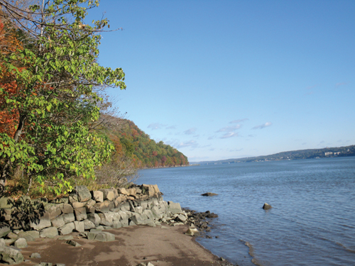
In another half mile, you’ll reach the Alpine Lookout, with outstanding views over the Hudson River. The trail follows a paved sidewalk along an iron railing around the perimeter of the lookout. This was the site of the “Rio Vista” estate, the home of Manuel Rionda (his manor house was located just south of the lookout). After reentering the woods, the trail reaches a fenced-in parapet that juts out over the river, with even better views up and down the river.
In another third of a mile, the trail approaches the Parkway. Just ahead, a sign and three red blazes mark the start of the Huyler’s Landing Trail. Turn left and follow this red-blazed trail which descends to the river along the route of an old road (in places, the road has narrowed to a footpath). After a sharp switchback to the right, the trail emerges on the paved Henry Hudson Drive. Turn left, follow the paved road for 300 feet, then bear right at a chain and continue to descend on a wide woods road. You’ll reach the river at an old picnic area, with an abandoned stone jetty just ahead. Turn left and follow the white-blazed Shore Trail, which follows a path between the cliffs on the left and the river on the right, passing several former beaches along the river. In half a mile, the trail climbs stone steps and follows a path above the river level. After crossing a wooden bridge over a stream, you’ll pass a plaque affixed to a rock on the left placed in memory of John Jordan, the first Superintendent of the Park, who died here in 1915.
A short distance beyond, you’ll reach a grassy area at the southern end of the Alpine Boat Basin. Continue north through the parking area, then proceed past the historic Kearney House, a small white building on the left which is the oldest building in the Park. The oldest part of the house— which once served as Park Headquarters—dates back to the 18th century. The Kearney House was significantly damaged during Hurricane Sandy in October 2012 and is currently being restored.
Just beyond the Kearney House, you’ll notice a plaque on the left entitled “Old Alpine Trail,” which states that the trail you are about to use to climb the Palisades was used by British troops in 1776 during the American Revolution. (As an adjacent sign points out, the information on this 85-year-old plaque is no longer considered to be historically accurate.) Bear left here and climb the old stone-paved road. At the top of the rise, turn sharply left and continue uphill on the road, now marked with the orange blazes of the Closter Dock Trail. When you reach the underpass on the left, continue ahead to the Administration Building, where the hike began.
This hiking article is provided by Daniel Chazin of the New York-New Jersey Trail Conference, a volunteer organization that builds and maintains over 1,850 miles of hiking trails. The Trail Conference also publishes many trail maps and guidebooks, including a five-map set for Hudson Palisades Trails ($8.95). For more information, go to www.nynjtc.org or e-mail HikeoftheWeek_aol.com.
By Daniel Chazin